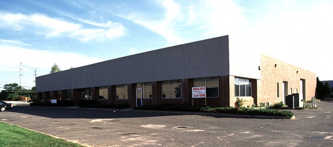
Property Record
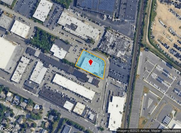
10 Aerial Way, Syosset, NY 11791
NEARBY LISTINGS FOR SALE OR LEASE
Property Detail
10 Aerial Way
Nassau County-Suffolk County, NY
Map Of Locust Grove Industrial Park
2489-15-161-00-0010-0
TOWN #3 SCH DIST 014
Warehouse
Nassau
X
New York
36059C0145G
10
2025
1.12 AC
2025
Eastern Nassau
518700
Long Island (New York)
19,895 SF
DEMOGRAPHICS near 10 Aerial Way
1 Mile
3 Mile
5 Mile
2024 Total Population
12,761
95,821
226,821
2029 Population
12,583
94,504
223,297
Pop Growth 2024-2029
(1.39%)
(1.37%)
(1.55%)
Average Age
41
42
42
2024 Total Households
3,856
30,349
71,369
HH Growth 2024-2029
(1.56%)
(1.45%)
(1.63%)
Median Household Inc
$165,398
$148,426
$139,747
Avg Household Size
3.20
3.00
3.00
2024 Avg HH Vehicles
2.00
2.00
2.00
Median Home Value
$777,492
$755,367
$711,921
Median Year Built
1956
1957
1956
Nearby Places
- Restaurants
- Banks
- Shops
- Fitness
- Groceries
PUBLIC TRANSPORTATION
COMMUTER RAIL
Syosset Station (Port Jefferson Branch - Long Island Rail Road)
DRIVE
WALK
Distance
Syosset Station (Port Jefferson Branch - Long Island Rail Road)
7 min
3.0 mi
Hicksville Station (Montauk Branch - Long Island Rail Road, Port Jefferson Branch - Long Island Rail Road, Ronkonkoma Branch - Long Island Rail Road)
DRIVE
WALK
Distance
Hicksville Station (Montauk Branch - Long Island Rail Road, Port Jefferson Branch - Long Island Rail Road, Ronkonkoma Branch - Long Island Rail Road)
6 min
3.2 mi
AIRPORT
John F Kennedy International
DRIVE
WALK
Distance
John F Kennedy International
37 min
21.9 mi
LaGuardia
DRIVE
WALK
Distance
LaGuardia
35 min
22.7 mi
Westchester County
DRIVE
WALK
Distance
Westchester County
65 min
43.0 mi
Freight Ports
NY - Red Hook Container Terminal
DRIVE
WALK
Distance
NY - Red Hook Container Terminal
47 min
30.8 mi
Nearby Properties
Address
Land Use
TOTAL SIZE
Lot Size
Zoning
Address
Land Use
TOTAL SIZE
Lot Size
Zoning
114,205 SF
14.06 AC
497
Address
Land Use
TOTAL SIZE
Lot Size
Zoning
Address
Land Use
TOTAL SIZE
Lot Size
Zoning
729,696 SF
579.18 AC
Address
Land Use
TOTAL SIZE
Lot Size
Zoning
Address
Land Use
TOTAL SIZE
Lot Size
Zoning
Address
Land Use
TOTAL SIZE
Lot Size
Zoning
55,780 SF
64 AC
Address
Land Use
TOTAL SIZE
Lot Size
Zoning
Address
Land Use
TOTAL SIZE
Lot Size
Zoning
178,486 SF
53.25 AC
Address
Land Use
TOTAL SIZE
Lot Size
Zoning
469,586 SF
53.14 AC
Address
Land Use
TOTAL SIZE
Lot Size
Zoning
800 SF
45.25 AC
Address
Land Use
TOTAL SIZE
Lot Size
Zoning
300,526 SF
44.30 AC
Address
Land Use
TOTAL SIZE
Lot Size
Zoning
160 SF
241.23 AC
Address
Land Use
TOTAL SIZE
Lot Size
Zoning
659,098 SF
34.76 AC
Address
Land Use
TOTAL SIZE
Lot Size
Zoning
Address
Land Use
TOTAL SIZE
Lot Size
Zoning
1,068,978 SF
56.12 AC
Address
Land Use
TOTAL SIZE
Lot Size
Zoning
2,555 SF
284.67 AC
Address
Land Use
TOTAL SIZE
Lot Size
Zoning
143,519 SF
20.67 AC
Address
Land Use
TOTAL SIZE
Lot Size
Zoning
Address
Land Use
TOTAL SIZE
Lot Size
Zoning
505,020 SF
58.54 AC
Address
Land Use
TOTAL SIZE
Lot Size
Zoning
Address
Land Use
TOTAL SIZE
Lot Size
Zoning
332,290 SF
25.91 AC
Address
Land Use
TOTAL SIZE
Lot Size
Zoning
331,084 SF
26.95 AC
Address
Land Use
TOTAL SIZE
Lot Size
Zoning
29,574 SF
174.23 AC
Address
Land Use
TOTAL SIZE
Lot Size
Zoning
146,287 SF
48.63 AC
Address
Land Use
TOTAL SIZE
Lot Size
Zoning
77,284 SF
40.86 AC
Address
Land Use
TOTAL SIZE
Lot Size
Zoning
159,471 SF
28.50 AC
Address
Land Use
TOTAL SIZE
Lot Size
Zoning
12,261 SF
12.83 AC
Address
Land Use
TOTAL SIZE
Lot Size
Zoning
60,571 SF
127.50 AC
Address
Land Use
TOTAL SIZE
Lot Size
Zoning
130,994 SF
27.94 AC
Address
Land Use
TOTAL SIZE
Lot Size
Zoning
The World's #1 Commercial Real Estate Marketplace
Connect with us
© 2025 CoStar Group
The information above has been obtained from sources believed reliable. While we do not doubt its accuracy we have not verified it and make no guarantee, warranty or representation about it. It is your responsibility to independently confirm its accuracy and completeness. Any projections, opinions, assumptions, or estimates used are for example only and do not represent the current or future performance of the property. The value of this transaction to you depends on tax and other factors which should be evaluated by your tax, financial, and legal advisors. You and your advisors should conduct a careful, independent investigation of the property to determine to your satisfaction the suitability of the property for your needs.